John Deere has recently been working with the satellite industry and will be picking a low-orbit satellite partner to help solve connectivity issues with farmers.
In a Jan. 3 report from CNBC, John Deere’s Chief Technology Officer Jahmy Hindman said the company is aiming to “create a geospatial map for farmers to use to better track productivity and the performance of crops.”
“There’s so much friction and getting that data from the field into the cloud, where they can do something useful with it, that it really isn’t used very effectively at all,” Hindman told CNBC. He also said John Deere’s budget for tech investments in 2023 will be in line with what it was in 2022. Deere’s 2022 R&D spending reached a record high of $1.9 billion in 2022.
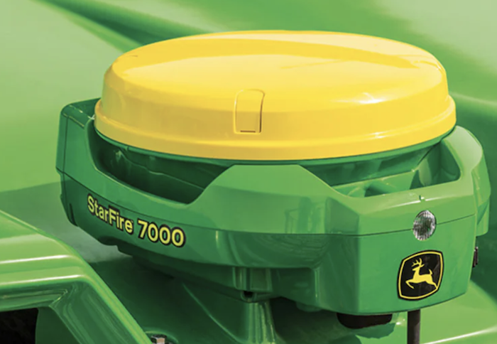
Two weeks later, Real Agriculture reported on John Deere’s StarFire 7000 GPS receiver, released in March 2022, and its satellite connection abilities, saying, “There is a yearly subscription for the satellite signal use, and pricing for the will be announced later this year.”
Deere’s website describes the StarFire 7000’s SF-RTK correction level as providing, “1-inch horizontal accuracy without the need for additional hardware. This is an improvement of 17% from the previous generation of StarFire receiver. The SF-RTK signal uses two additional satellite constellations (BeiDou and Galileo) as well as both GPS (United States) and GLONASS (Russia) satellites. SF-RTK uses satellite corrections only and does not require the use of an RTK Radio.”
Commenting on the buzz around John Deere and satellites in a Jan. 8 newsletter, Analyst with Upstream Ag Insights Shane Thomas added that John Deere had alluded to enabling satellite connectivity on its equipment before, having previously stated it wanted a solution in place by mid-2024.
“CTO Jahmy Hindman alluded to enabling equipment to receive satellite sent connectivity at the Leaps Unlocked event in May, but Deere officially issued an RFP (request for proposal) in October to the satellite industry:
“‘Deere is seeking a strategic partnership with a vendor or set of vendors to connect both new machines and retrofitted machines with satellite service and ruggedized satellite terminals,’” said Thomas.
And John Deere isn’t the only one looking at satellite connectivity as of late. South African company Dragonfly Aerospace announced Jan. 3 it had launched its first imaging satellite, the EOS SAT-1 — billed as the world’s first “agri-focused satellite” — for EOS Data Analytics, a global geospatial analytics provider that creates satellite-driven solutions for agriculture, forestry and mining applications. Dragonfly aims to launch 6 more satellites by 2025.
Images obtained from Dragonfly’s EOS SAT-1 will deliver information for harvest monitoring, application mapping, seasonal planning and assessments that analyze information such as soil moisture, yield prediction and biomass levels.
Equipped with 2 DragonEye electro-optical imagers, EOS SAT-1 will provide 44 kilometer (27 mile) swath panchromatic and multispectral imagery across 11 spectral bands at close to 1m resolution.


Post a comment
Report Abusive Comment